Nhân Chủ-Chủ Quyền Cá Nhân Con Người-Thượng Đế, Nhà Nước là Ảo Thể- Chúng Ta là Thực Thể- Không có Thượng Đế, Không có Nhà Nước, Chỉ có Chúng Ta, Tôi và Quí Vị phải Quyết Định Phương Cách Tự Trách Nhiệm Trao Đổi để Sống Chung Tự Do, Bình Đẳng với Nhau Mà Thôi!
Bọn Nhà nước Trung Quốc đã vừa hoàn tất ý nguyện mà đám nhà nước Mỹ đã khởi sự: Kiểm soát sự giao lưu Internet hoàn toàn vì nhu cầu bảo vệ bản sắc, luân lý đạo đức và an ninh quốc gia - với việc hoàn tất BỨC VẠN LÝ TƯỜNG LỬA (the Great Firewall) Những quí vị "to mồm tự do dân chủ chống cộng" đừng vội nhảy đỏng chỉ tay xỉa sói Tầu!
Khi làn sóng Internet khởi đi từ Mỹ tràn ngập thế giới và tràn vào Trung Quốc, người ta "cứ sai lầm" cho rằng "nhà nước Mỹ" đã xuất cảng tự do thông tin ngôn luận toàn cầu. Nhưng nhờ kẻ "phản quốc" yêu tự do nhân bản Edward Snowden và Julian Assange, nhân loại mới biết rằng bọn nhà nước và tập đoàn Âu Mỹ Mỹ Úc đã thiếp lặp một mô thức kiểm soát rình mò và kiểm duyệt trong hệ thống internet toàn cầu tưởng là tự do của nó. Đứng đầu bảng hợp tác cùng NSA là Google.
Mỉa mai thay, NẠN NHÂN bị Vạn Lý Tường Lửa "chặt" lại chính là Google Gmail !!!
Buổi hội thảo hợp tác này do hai nhân vật quan chức cao cấp Hoa Mỹ chủ tọa: Thứ trưởng ngoại giao Mỹ Catherine Novelli, (US Undersecretary of State) và Lu Wei, bộ trưởng Kiểm Soát Mạng Thông Tin Toàn Cầu TQ (Minister of the Cyberspace Administration of China.)
Nhân danh an ninh quốc gia, bảo vệ bản sắc văn hóa, tất cả bọn nhà nước, không chỉ riêng Tầu đã và đang nỗ lực mọi cách ngăn chặn TỰ DO THÔNG TIN, NGÔN LUẬN và kiểm soát giao lưu thông tin giữa những cá nhân và giữa các xã hội.
Ngay cả bọn tôn giáo, nhân danh bảo vệ đạo đức luân lý cũng đang nỗ lực vận động những biện pháp KIỂM DUYỆT THÔNG TIN.
Nói tóm gọn lại quyền lực, dưới bất cứ hình thức nào cũng đều sợ TỰ DO THÔNG TIN. Sau đây là danh sách những cơ quan tổ chức công ty ỦNG HỘ ĐẠO LUẬT KIỂM SOÁT và KIỂM DUYỆT INTERNET của nhà nước Việt Nam .. Trung Cộng ..."dân chủ tự do Mỹ!!!
Chưa hết, sau việc thành công xây dựng "bức vạn lý tường lửa" này, nhà nước Tầu đã dấy động thêm một làn sóng những người Tầu yêu tổ quốc, bản sắc văn hóa phương Đông Trung Quốc "xung phong" góp phần kiểm soát và kiểm duyệt mạng bảo vệ quốc gia văn hóa phương đông Trung Quốc chống những xâm nhập và lũng đoạn nền văn hóa, văn minh bản sắc của Tầu.Patriotic Chinese Blogger Embodies Beijing’s Web Vision.
Chúng ta hãy đợi xem không chỉ những trò bán khai man rợ nhân danh đủ thứ này của bọn quyền chính sẽ nối đuôi nhau công khaI diễn trò ngăn chặn quyền thông tin ngôn luận, xâm phạm quyền riêng tư của người dân, mà sẽ không ít các CON DÂN YÊU NƯỚC, TÍN ĐỒ TÔN GIÁO sẽ nối đuôi nhau nỗ lực phá hoại nền thông tin tư tưởng của nhân loại. Một hành động không chỉ bán khai man rợ, mà tối dạ đầy tuyệt vọng, vì KHÔNG MỘT AI, MỘT QUYỀN LỰC NÀO, nhà nước nào, kể cả gã Thượng Đế hay tên Thiên Chúa, hoặc gã Alah có khả năng ngăn chặn được tự do của tư tưởng...Lịch sử hàng chục ngàn năm qua đến hôm nay đã khẳng định sức mạnh của tự do, sức mạnh của tư tưởng.
Chỉ có những kẻ bất lực bất trí, bất nhân mới cần quyền bính và bạo lực Chỉ có những kẻ quyền bính, bệnh hoạn tâm thần, yếu hèn, thiếu bản lãnh mới sợ TỤ DO. Chỉ có những kẻ thích bạo lực, sợ tự do mới cần định chế quyền chính
Mỗi cá nhân chúng ta, những người yêu tự do, sẽ không để bọn quyền chính nhân danh bất cứ điều gì phá hủy phương tiện tự do của chúng ta.
Ai muốn khóa cửa bảo vệ bản sắc nhà mình, xin cứ tự nhiên. Nhưng xin đừng hé cửa nhìn lén thèm thuồng tự do của kẻ khác mà ghen tị căm thù!
China has upped the ante in its longstanding censorship of all things Google. In the six months since Google’s mail service Gmail was blocked in mainland China, users had been able to access it using third-party email applications such as Microsoft Outlook or Apple Mail. Beijing now appears to have closed the loophole, completely shutting down access to Gmail behind the so-called Great Firewall. Google data showed Gmail appeared to have been walled off starting Friday. Google spokesman Taj Meadows acknowledged the drop in traffic and said Monday that “there’s nothing wrong on our end.” China’s State Internet Information Office did not immediately respond to a request for comment Monday. At a daily press briefing, Foreign Ministry spokeswoman Hua Chunying said she wasn’t aware of the matter. She added that the government “always welcomes foreign businesses to carry out relevant work in China.”
Advertisement
Beijing doesn’t always publicize its reasons for shutting down websites, permanently or temporarily. In the past, such censorship has tended to coincide with periods of politically sensitive anniversaries or big political conferences in the capital like its annual legislature. The last time Google came under such attack was in June, ahead of the 25th anniversary of Beijing’s deadly suppression of the Tiananmen Square pro-democracy protests. During that round, Google’s suite of services including Google+, Gchat and Drive were all shut down. It was the first time that Beijing had blocked Google services to such a significant extent ahead of a Tiananmen anniversary. The Wall Street Journal’s English- and Chinese-language websites were also blocked around that time.
Google clashed with Beijing in 2010 after the company decided to stop censoring its Internet search results in China. Google shifted most of its Chinese operations to Hong Kong as a result, and it has been hard since then to access the company’s services on the mainland. As with Google search functions, Gmail users will now have to access the application through virtual private networks or other censorship circumvention channels, putting the email service on par with Facebook and Twitter in the eyes of Beijing censors. –Chuin-Wei Yap, with contributions from Yang Jie
Chúng ta không chỉ BỊ vận hành thụ động trong một nền kinh-tế-chính-trị, thờ phượng trong một nền tôn-giáo-chính-trị, hành xử trong một nền "văn-hoá-chính-trị", mà còn bị sử dụng trong một nền khoa-học-chính-trị. Tất cả là công cụ của nhu cầu quyền lực cai trị.
Giáo sư Prof Michel Chossudovsky người điều hành trung tâm nghiên cứu toàn cầu, trong ngày giáng sinh năm nay, vừa nhắc lại sự kiện sóng thần tại Nam Dương cách đây 10 năm, 26-12-2004, hàng chục ngàn "người dân nghèo khó lạc hậu hồi giáo" tại Aceh đã bị cuốn trôi.
Ngay sau đó, nếu chúng ta còn nhớ, là một trận đổ bộ của quân đội Mỹ Úc đã chực sẵn và nhào vào "cứu trợ" Nam Dương, nhưng đã được chính phủ Nam Dương "cương quyết cảm ơn" và từ chối "cứu trợ quân sự" (tk3).
Những tuần sau đó là những bản tin đổ lỗi cho "hệ thống báo động đất quốc tế" là không hữu hiệu, và rằng sự liên lạc quốc tế (Pacific Tsunami Warning Center (PTWC) không đáo ứng kịp thời v.v
Thật sự, trên thế giới, một hệ thống liên lạc báo động chặt chẽ do Mỹ chủ động cùng các viện khoa học nghiên cứu cũng như các văn phòng khoa học khí tượng của các quốc gia có tầm đe doạ động đất, hoạt động thật hữu hiệu, Những cơ quan với những kỹ thuật tế vi này có khả năng cung cấp những THÔNG TIN, HÌNH ẢNH VỆ TINH ngay tức thời (in real time) của các chấn động, và có khả năng thông báo rộng rãi trong một hai phút (tk1).
Theo bản tường trình của viện đại học Columbia University’s Earth Institute - Vụ sóng thần này do một tác động địa chấn tương đương 700 triệu quả bom nguyên tử thả tại Hiroshima!
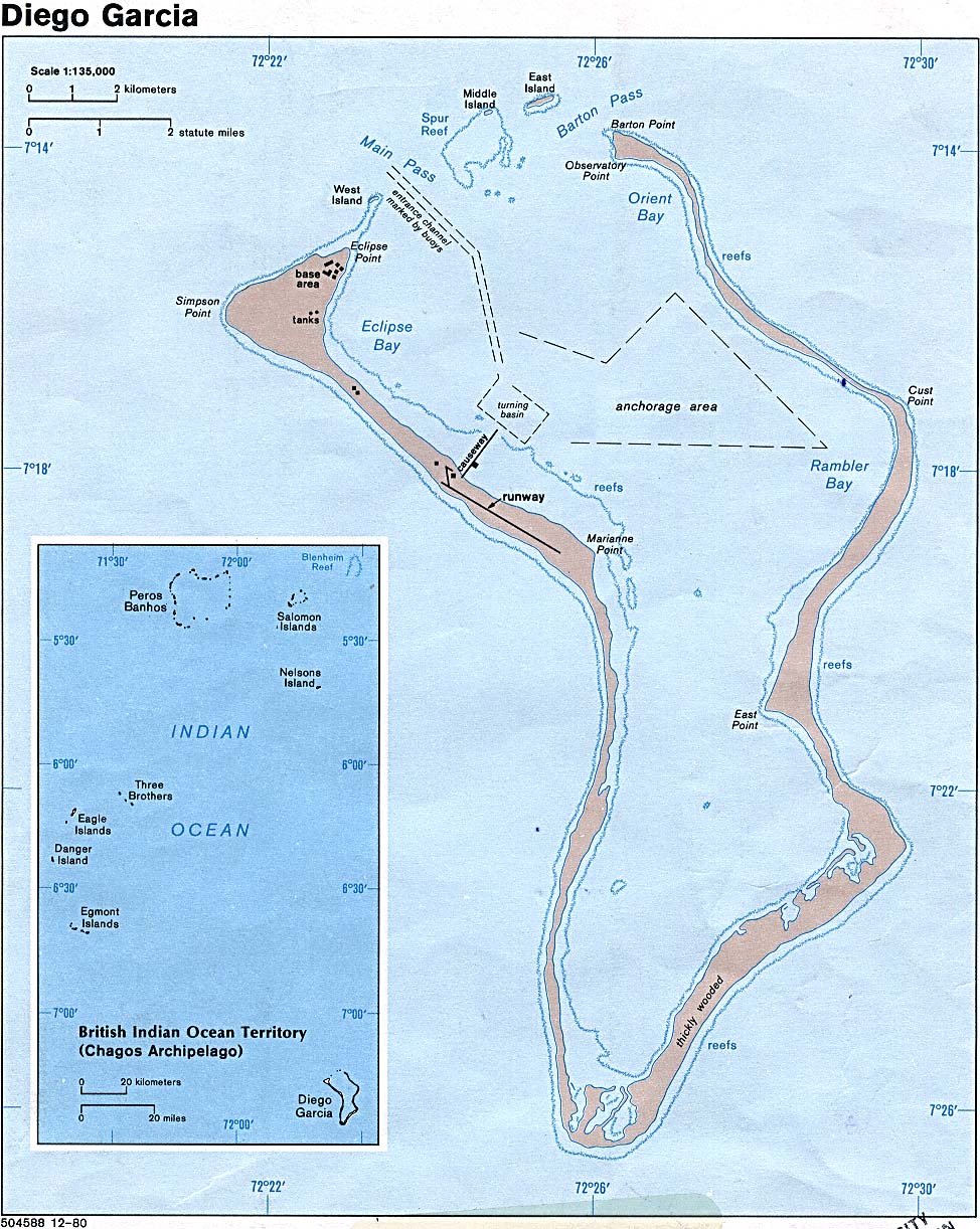
-Tất cả những thông tin dự báo của vụ địa chấn này đều có sẵn ngay tức thì (real time) tại các trung tâm theo dõi chính như ở Hawaii (Pacific Tsunami Warning Center (PTWC) hoặc tại căn cứ quân sự tối tân của Mỹ tại Diego Garcia, Ấn Độ Dương.
Theo bản tin sớm nhất của trung tâm PTWC, từ Hawaii thông báo về chi tiết vụ địa chấn vào lúc 01.14 GMT (giờ quốc tế), nghĩa là SAU khi cơn sóng thần (Tsunami) đả càn quét Aceh miền bắc Sumatra kéo đi hàng ngàn nhân mạng.
Một cách chính thức, sau khi sự kiện sóng thần xảy ra, thì trung tâm theo dõi địa chấn tại Hawaii đã thông báo đầy đủ những tin tức địa chấn về Washington và căn cứ quân sự của Mỹ Diego Garcia tại Ấn Độ Dương. Các cơ quan của Mỹ đều nắm biết những thông tin chi tiết này từ cơ quan (National Earthquake Information Center (NEIC) tại Golden, Colorado,
Những chi tiết về địa chấn này được gửi đi từ 4 trung tâm theo dõi địa chấn của Mỹ tại Ấn Độ Dương International Deployment of Accelerometers (IDA) Project "chỉ 3 phút 30 giây sau cuộc động đất (“Received signals three minutes, thirty seconds after the quake began”) ... Nhưng toàn bộ "im lặng" không thông báo cho những tụ điểm hậu quả của cuộc địa chấn kinh khủng này!
Nhưng thực tế, theo các bản tường trình thì chính căn cứ Mỹ military base at Diego Garcia tại Ấn Độ Dương với những kỹ thuật tế vi mới là "nguồn gửi" đi các thông tin này, chứ không phải là nơi "nhận" hoặc "tiếp vận" thông tin, Có nghĩa là căn cứ Mỹ tại đây Diego Garcia đã có những thông tin địa chấn ngay tức thì nhưng KHÔNG THÔNG BÁO cho Nam Dương và các quốc gia nằm trong tác động của địa chấn.
Vấn đề không chỉ là căn cứ Diego Garcia mà còn ngay cả trung tâm theo dõi của Âu Châu cũng nằm trong "hệ thống báo động thế giới" (The European Space Agency (ESA ) cũng nắm vững các thông tin này sớm nhất... nhưng cũng không thông báo!
Sự kiện này có nghĩa là cái gọi là "Hệ Thống Cảnh Báo Toàn Cầu" (Global Warning System) do các chính phủ tiến bộ chủ động, một cách nào đó đã "từ chối" không làm việc, không phát lệnh cảnh báo sóng thần, dù nắm rõ đầy đủ thông tin một cuộc động đất lớn nhất trong lịch sử cận đại với khả năng tạo một làn sóng thần như đã xảy ra!
Sự kiện 911 (2001) cũng đã đặt cho thế giới một câu hỏi khó trả lời xuôi lọt rằng tại sao trên 15 (Mỹ) + Do Thái, Úc , Anh, Nga , Đức, Âu Châu, cơ quan tình báo thượng thặng của Âu Mỹ Do Thái với kỹ thuật rình mò nghe lén tối tân NSA, CIA, phối hợp chặt chẽ và rộng rãi, cũng như hệ thống phòng thủ không phận và trả đũa cao cấp như thế của Mỹ, lại có thể "tạm ngưng làm việc" tê liệt trong vòng 2 giờ đồng khi 4 chiếc may bay hàng không dân dụng bị "không tặc" và lẩn quẩn trên vùng trời của nước Mỹ trong khoảng thời gian dài như vậy? Và vụ sóng thần tại Aceh Nam Dương 3 năm sau, 2004, cũng đặt thế giới thêm một câu hỏi "trùng hợp" tương tự như thế, rằng tại sao MỘT HỆ THỐNG LIÊN LẠC CHẶT CHẼ TOÀN CẦU với những thiết bị tế vi của những quốc gia tân tiến như thế, đã nắm vững các dữ kiện động đất như thế, nhưng lại CHẬM TRỄ "luộm thuộm" không tuân thủ theo đúng nguyên tắc CẢNH BÁO (warning procedures) đã đề ra- trong vụ địa chấn đã đưa đến cơn sống thần, mà lẽ ra đã có thể cảnh báo đúng lúc đủ thời gian và có khả năng cứu được hàng ngàn sinh mạng người dân vùng Aceh? Tất cả đã được quyết định bởi chính trị chăng? Tùy độc giả tham khảo rộng thêm và có qui kết riêng. nkptc ======================
Ten Years Ago: December 26, 2004: Indian Ocean Tsunami. Why did the Information Not Get Out? Was There a Hidden Agenda?
This article was first published in February 2005. The tsunami warning system was also examined by the author in two texts published in the immediate wake of the December 26, 2004 tsunami
The text below examines the broader seismic network as well as the system of satellite imagery, which provides data in near real time.
SUMMARY (Scroll down for text of complete article) One of the most destructive and powerful earthquakes in recorded history, more than a quarter of a million recorded deaths, local economies destroyed, the lives of entire communities shattered, and no serious investigation into the flaws of the global seismic warning system is contemplated.
According to Columbia University’s Earth Institute the M-9.0 Sumatra – Andaman Island earthquake on December 26th released energy, equivalent roughly to 700 million Hiroshima bombs. Seismic information regarding what scientists identify as a “rare great earthquake”, was available in near real time (i.e. almost immediately) to seismic centers around the World. Other types of data, including satellite imagery were also available in near real time. The advanced global seismic information and communications systems were fully operational. Why then, did the information not get out on the morning of December 26th? Ten of thousands of lives could have been saved. The issue has been skirted by the Western media, sidestepped by the governments and the UN, not to mention the international scientific community. 1- What Happened on the Morning of December 26th? The tsunami was triggered within minutes of the earthquake, prior to the release of the first tsunami advisory bulletin by the Pacific Tsunami Warning Center (PTWC) in Hawaii, so it was no longer a question of emitting “a warning” of an imminent danger. The catastrophe had already happened.
In other words, by the time the first tsunami bulletin had been issued at 01.14 GMT, the deadly seismic wave was already sweeping Banda, the capital of Aceh province in Northern Sumatra, causing thousands of deaths.
This ex post facto bulletin emitted by the PTWC, did not even warn of the potential danger of a tsunami. Moreover, it casually dismissed an established and scientifically accepted relationship:
“If it were a 9 earthquake … with the thrusting in an ocean basin margin, the likelihood is almost 1:1 that it would generate a tsunami” (Dr. Charles Groat, Director, US Geological Survey in testimony to the Science Committee of the US House of Representatives, 26 Jan 2005). Tip of the Iceberg
The PTWC bulletins are but the tip of the iceberg. The information on the quake was known and available in real time, to an entire network of seismic organizations. It was also on hand and accessible to a number of government agencies both in the US and internationally, almost immediately. Numerous officials, scientists, members of the military and intelligence services, had advanced knowledge of an impending disaster. In other words, we are not dealing with the failures of a single warning Center in Ewo, Hawaii, but with an entire Worldwide network of seismic information, satellite imagery and other sophisticated data, which was available almost immediately.
Who informs Whom?
The question is not why the PTWC did not emit a tsunami warning, but why did an entire global network of scientists and officials not emit a warning, in relation to one of the largest quakes in recorded history.
While the PTWC had indeed formally notified Washington and the Military at the Diego Garcia island base, the US government and military already knew, because the seismic data had been processed within minutes by an agency under the jurisdiction of the US Department of the Interior, namely the National Earthquake Information Center (NEIC) based in Golden, Colorado.
The data regarding the magnitude of the earthquake originated from four seismic stations located in the Indian Ocean, operated by the International Deployment of Accelerometers (IDA) Project . “Received signals three minutes, thirty seconds after the quake began” In testimony to the US Congress (Jan 26, 2005), Scripps (SIO) Deputy-Director John Orcutt which overseas the Indian Ocean IDA seismic stations confirmed that on December 26, the data pertaining to the Sumatra-Andaman quake had been “immediately and automatically forwarded by computer to the USGS National Earthquake Information Center (NEIC) in Golden, Colorado and the NOAA tsunami warning centers in Hawaii and Alaska”
The US Military Base at Diego Garcia
The first news reports underscored the fact that the US military base at Diego Garcia had been given advanced warning, but that the information reached military officials at the US island naval base “after” the tsunami had hit India and Sri Lanka:
”An NOAA log shows that the US Pacific Command, including Diego Garcia, was given a specific warning about the tsunami some two and three quarter hours after the earthquake” (The Guardian, 7 Jan 2005)
These earlier reports must be qualified. The fact of the matter, is that the data concerning the earthquake originated from monitoring stations situated in the Indian Ocean, including the The IDA/IRIS seismic station DGAR (Diego Garcia) seismic station located directly on the site of the US island military base.
There are in all four monitoring stations in the Chagos archipelago, which use the communications system of the US military base.
In other words, the US military base at Diego Garcia , with its advanced monitoring facilities, research labs, etc. was not the “recipient” but rather “the source” of the relevant data regarding the earthquake.
Satellite Imagery transmitted in Real Time
In addition to real time seismic data (as well as hydroacoustic, infrasound and radionuclide data transmitted out of Diego Garcia), satellite images of the disaster on the North Sumatra coastline were also available in near real time to a number of agencies and international organizations. The US has an advanced “spy satellite” system, with very precise capabilities of monitoring the terrain, including changes in the natural environment, not to mention moving objects. The National Reconnaissance Office (NRO), which was responsible for launching the first spy satellites of the Cold War era operates a sophisticated system of reconnaissance satellites, which transmit imagery and other data in real time.
Another key US body, involved in satellite imagery is the National Geospatial-Intelligence Agency, (NGA) , formerly known as the National Imagery and Mapping Agency. The latter was in fact the architect of the global positioning system (GPS), which was conducive to creating a system of global geospatial intelligence (GEOINT).
NGA is part of the US defense system, it serves the Department of Defense and the intelligence community. It has very precise capabilities of monitoring the geographic and physical terrain by satellite, all over the world, using the techniques of geospatial intelligence (GEOINT). In other words, state of the art satellite imagery (available to military, intelligence, civilian as well as private commercial entities) provides “a real time set of eyes”. With regard, to the M-9.0 tsunami of December 26, satellite images were available almost immediately. The US military confirms in this regard, that it has access from its satellite systems “to vital intelligence in real time”. These real time images were used extensively in the Iraq and Afghan war theaters. (Hearings of Sen Armed Services Committee, 25 Feb 2004).
The Role of the European Space Agency Real time seismic and other data (including satellite imagery) were also available to a number of countries including Russia, China, Japan and the European Union.
In this regard, The European Space Agency (ESA ), which has links to NOAA, has “multi-sensor access” in real time to data from satellites including very precise imagery which allows: Them ”for complete large-scale phenomena to be observed to an accuracy and entirety it would take an army of ground level observers to match”
In addition to imagery, the satellite transmits other relevant data which measures very accurately “ground motion” and “sea height”:
While “before” and “after” images of the disaster have been made public, the images which show the progress and movement of the tsunami, in the period immediately following the earth quake have not been released.
Concluding Remarks: The Need for an Investigation into the Warning System More than a quarter of million people have died in one of the World’s most devastating natural disasters. The overriding issues pertaining to the warning / information systems, cannot be drowned or brushed aside. They must be the object of a full-fledged inquiry, preferably by an independent body. This report has outlined a number of broad issues pertaining to the global information network. The latter requires detailed examination in the context of full-fledged inquiry. What agencies in the US, the European Union, in the Indian Ocean countries and internationally were informed? The failures are by no means limited to the US seismic network. When were they informed? What type of data did they have? Some of that data has not been released. Why did the information not reach the people on time in the countries affected by the tsunami? What factors, administrative, scientific or otherwise, contributed to preventing the information from being transmitted? We are not dealing strictly with seismic data. Satellite images of the devastation in Northern Sumatra were also available. Other types of data were also transmitted in near real time by satellite. The approximate speed of the seismic wave was known and confirmed. According to the news reports, the tsunami was moving at a speed of roughly 20 km a minute (on average) in relation to Sri Lanka. The seismic information was known to the NEIC and other seismic centers within less than four minutes after the quake. The tsunami hit the Indonesian coast within 5 minutes, in other words 10 minutes before the release of the first TPWC bulletin. Banda Aceh was hit by the tsunami 11 minutes after the earthquake, approximately 3 minutes before the release of the TPWC bulletin. In other words, it was possible to predict in a very precise way, at what time the seismic wave would hit the coastlines of Thailand, Sri Lanka, India, The Maldives and Somalia. Had this information been transmitted in a consistent fashion, there would have been ample time to evacuate people from the coastal areas of Sri Lanka, India, not to mention the East coast of Africa. There are no Ocean sensors in the Indian Ocean. But this was not the cause of the failures and omissions in the warning system. The tsunami became active immediately following the earthquake. No warnings were sent out following the seismic readings despite the fact that the tsunami had already hit the Indonesian coast. This is the key issue. The Tsunami was active, and this was known, corroborated not only by seismic information but also by satellite images and other data, roughly 30 minutes prior to hitting Thailand. Michel Chossudovsky, December 26, 2014 TEXT OF COMPLETE ARTICLE
Indian Ocean Tsunami. Why did the Information Not Get Out?
by Michel Chossudovsky
December 26, 2004 One of the most destructive and powerful earthquakes in recorded history, more than a quarter of a million recorded deaths, local economies destroyed, the lives of entire communities shattered, and no serious investigation into the flaws of the global seismic warning system is contemplated. According to Columbia University’s Earth Institute the M-9.0 Sumatra – Andaman Island earthquake on December 26th released energy, equivalent roughly to 700 million Hiroshima bombs. Seismic information regarding what scientists identify as a “rare great earthquake”, was available in near real time (i.e. almost immediately) to seismic centers around the World. Other types of data, including satellite imagery were also available in near real time. The advanced global seismic information and communications systems were fully operational. Why then, did the information not get out on the morning of December 26th? Ten of thousands of lives could have been saved. The issue has been skirted by the Western media, sidestepped by the governments and the UN, not to mention the international scientific community. The blame was casually placed on the Indian Ocean countries, described as having “inadequate communications systems”, not to mention the local people who “have to be trained to know what to do…If the people don’t respond, don’t understand what the communication is all about, it is for naught.” (Washington Times, 30Dec 2004) What Happened on the Morning of December 26th? The tsunami was triggered within minutes of the earthquake, prior to the release of the first tsunami advisory bulletin by the Pacific Tsunami Warning Center (PTWC) in Hawaii, so it was no longer a question of emitting “a warning” of an imminent danger. The catastrophe had already happened. In other words, by the time the first tsunami bulletin had been issued at 01.14 GMT, the deadly seismic wave was already sweeping Banda, the capital of Aceh province in Northern Sumatra, causing thousands of deaths. Moreover, this ex post facto bulletin emitted by the PTWC, not only failed to acknowledge an ongoing disaster, it did not even warn of the potential danger of a tsunami, when the deadly seismic wave had already started, devastating densely populated areas. (PTWC bulletins apply to the Pacific as well as regions adjacent to the Pacific. For details, see:Discrepancies in the Tsunami Warning System ) Inconsistencies in the Tsunami Bulletins Three days earlier, on the 23d of December, a M-7.9 earthquake was recorded with an epicenter off the South Pacific MacQuarie islands The PTWC issued the following routine tsunami advisory:
“THIS EARTHQUAKE HAS THE POTENTIAL TO GENERATE A WIDELY DESTRUCTIVE TSUNAMI IN THE SEA NEAR THE EARTHQUAKE. AUTHORITIES IN THAT REGION SHOULD BE AWARE OF THIS POSSIBILITY.”
Why then in the case of a M-9.0 earthquake, which is more than ten times greater in magnitude than a M-7.9 earthquake, did the PTWC authorities fail to even issue a tsunami warning? An event of this type and magnitude is known as a “megathrust,” which in its specific Indian Ocean location is said to occur “approximately every few hundred years.” (See Columbia University Earth Institute ). Scientists in fact suggested that the quake had unleashed enough energy that “it could have rocked the earth off its axis.” (See: Huge quake resonates, Carolyn Y. Johnson, Boston Globe) In other words, the least one would have expected in the case of a “megathrust” was a similar routine statement to that issued in relation to the McQuarie islands earthquake, three days earlier, on December 23. (see:Discrepancies in the Tsunami Warning System ) The first bulletin emitted on the 26th not only failed to conform to established criteria used in previous and subsequent seismic occurrences, it casually dismissed an established and scientifically accepted relationship. According to
“If it were a 9 earthquake … with the thrusting in an ocean basin margin, the likelihood is almost 1:1 that it would generate a tsunami” (Dr. Charles Groat, Director, US Geological Survey in testimony to the Science Committee of the US House of Representatives, 26 Jan 2005).
The Earthquake took place at 00.58.50 GMT on the 26th of December. Roughly five minutes later it had hit the coast of Northern Sumatra, 11 minutes after the earthquake it devastated Banda, capital of Aceh. Fifteen minutes after the earthquake, at 01.14 GMT the Pacific Tsunami Warning Center in Hawaii confirmed in its bulletin:
“THERE IS NO TSUNAMI WARNING OR WATCH IN EFFECT”
Moreover, both official and news reports out of Aceh province, following the disaster, were either delayed or were not transmitted on time. In other words, despite the dramatic nature of the quake, the seismic information, which was available in real time, failed to reach the countries affected by the seismic wave. Why were the countries not informed of an impending disaster? In the words of Maine Senator Olympia Snowe:
“… what efforts, if any, were made to contact those other nations in the region that were also in harm’s way? If NOAA did not have the appropriate contacts, as has been reported, why was this the case? Was an attempt made to obtain that contact information – and if not, why not? These are questions that must be answered.”
The Western media not only failed to address the failures in the warning system, they admonished those who raised the issue. In fact, any serious analysis of the warning system was dismissed outright. A few press reports, nonetheless, confirmed that, with the exception of Indonesia and Australia, the Indian Ocean countries had not been informed. These same reports, largely based on statements of the Pacific Tsunami Warning system (PTWC) in Hawaii, also acknowledged that the US State Department and the Military, including the US Navy base on the island of Diego Garcia in the Chagos Archipelago had been duly notified. In retrospect, however, these earlier press reports (including our own analysis ) need to be qualified. Published in the immediate wake of the disaster, they quote official statements to the effect that the US government and military had been informed by the PTWC, when in fact the PTWC was on the “receiving end” of the flow of seismic data. (See Foreknowledge of a Natural Disaster , Richard Norton Taylor, US island base given warning: Bulletins sent to Diego Garcia ‘could have saved lives’, The Guardian, Jan 2005). The Information was Known to an Entire Network of Organizations Upon closer examination, the PTWC bulletins are but the tip of the iceberg: The information on the quake was known and available in real time, to an entire network of seismic organizations. It was also on hand and accessible to a number of government agencies both in the US and internationally, almost immediately. Numerous officials, scientists, members of the military and intelligence services, had advanced knowledge of an impending disaster. In other words, we are not dealing with the failures of a single warning Center in Ewo, Hawaii, but with an entire Worldwide network of seismic information, satellite imagery and other sophisticated data, which was available almost immediately. Who informs Whom? The question is not why the PTWC did not emit a tsunami warning but why did an entire global network of scientists and officials not emit a warning, in relation to one of the largest quakes in recorded history. While the PTWC had indeed formally notified Washington and the Military at the Diego Garcia island base, the US government and military already knew, because the seismic data had been processed within minutes by an agency under the jurisdiction of the US Department of the Interior, namely the National Earthquake Information Center (NEIC) based in Golden (close to Denver), Colorado.
“The National Earthquake Information Service (NEIS) of the U. S. Geological Survey is located at the National Earthquake Information Center (NEIC) in Golden, Colorado, USA which also serves as World Data Center A for Seismology. The NEIS is a member of the Council of the National Seismic System (CNSS) which coordinates activities among the national and regional seismograph networks, including “finger quake” services. The NEIS is also closely associated with the U.S. National Seismograph Network (USNSN) and cooperates with national and international seismological organizations around the world. Unlike other members of the CNSS, the NEIS is responsible for reporting on moderate to large earthquakes throughout the U. S. and large earthquakes worldwide… On an immediate basis, all Earthquake Early Alerting Service alarm events will be made available to the “quake” list. At a minimum, this includes… most foreign earthquakes of magnitude 6.5 or greater. In practice, many foreign earthquakes smaller than a magnitude of 6.5 will also be provided on an immediate basis…” For further details: See http://neic.usgs.gov/neis/finger/qk_info.html , http://neic.usgs.gov/neis/finger/qk_info.html , http://neic.usgs.gov/neis/bulletin/neic_slav_ts.html , http://neic.usgs.gov/neis/bulletin/neic_slav_ts.html , http://earthquake.usgs.gov/eqinthenews/2004/usslav/neic_slav_faq.html
The seismographic data did not originate at the PTWC, which is part of the Weather Service of the National Oceanic and Atmospheric Administration (NOAA) under the jurisdiction of the US Department of Commerce. The seismic data was recorded both within the Indian Ocean region and around the World by a number of stations, relayed to a network of seismic centers in a number of countries. (see below). In other words, omissions and failures in the warning system, not to mention red tape, were by no means limited to the PTWC, which is integrated into a global information network which records, processes and transmits seismic data in near real time. Several key organizations (including the Earthquake Information Center World Data Center for Seismology, Denver (NEIC) and The European Space Agency (ESA) among others, are part of this network, and could have duly advised the countries concerned. Where did the seismic data originate from? This issue, which is crucial to understanding the flaws in the seismic warning system, was barely mentioned by the media. The data regarding the magnitude of the earthquake originated from four seismic stations located in the Indian Ocean, operated by the International Deployment of Accelerometers (IDA) Project . The Scripps Institution Of Oceanography (SIO) at the University Of California at San Diego overseas the IDA seismic stations. In turn, the IDA is integrated into the Incorporated Research Institutions for Seismology (IRIS) and its Global Seismographic Network (GSN ), and into the data system of the National Earthquake Information Center World Data Center for Seismology, Denver (NEIC (WDCS-D)). (See Eric Waddell, The Tsunami: Why Weren’t They Warned? Jan 2005, http://globalresearch.ca/articles/WAD501A.html ) “Received signals three minutes, thirty seconds after the quake began” In testimony to the US Congress (Jan 26, 2005), Scripps (SIO) Deputy-Director John Orcutt confirmed that “data telemetry”, namely the transfer of data immediately via phone line, cable, or satellite is central to the SIO’s mandate: “Data acquired via telemetry may be used … as [a] :tsunami warning:… Prompt transmission of the seismic data permits experts to locate earthquakes quickly, assess the likelihood they have generated a tsunami, and predict when the destructive wave will arrive. Such predictions have already saved numerous lives.”(SIO’s Project IDA, http://ida.ucsd.edu/Telemetry/index.html ) Scripps Dr. Orcutt also confirmed that on December 26, the data pertaining to the Sumatra-Andaman quake had been telemetered from 30 IDA stations and had been “immediately and automatically forwarded by computer to the USGS National Earthquake Information Center (NEIC) in Golden, Colorado and the NOAA tsunami warning centers in Hawaii and Alaska”: “Due to their proximity to the event, IDA stations were critical in the early detection of the December 26th earthquake. The two closest global seismic stations, IDA stations on Cocos (Keeling) Island and Sri Lanka, received signals three minutes, thirty seconds after the quake began. Data from these and other IDA GSN stations in the region were used by the NEIC, and other civil, academic, and military systems to quickly determine the quake’s size and location.” (Statement to the Science Committee of the US House of Representatives, 26 Jan 2005. emphasis added). Contradicting the substance of his own testimony, Dr. Orcutt stated that Scripps (SIO) officials got the news from the NEIC, by email one hour and 17 minutes after the earthquake, when in fact it was the Scripps IDA stations, that had transmitted the data in near real time to the NEIC in the first place, and that this data had been made available to other agencies, in the US and internationally:
“Scripps staff first learned of the quake at 6:16 PM PST (one hour seventeen minutes after the earthquake) when they received notice via automatic email from the NEIC of the initial earthquake detection. SIO [Scripps Institution of Oceanography] also received an inquiry from the IDA/Sri Lanka operator at 6:57PM (one hour fiftyeight minutes after the quake) asking whether there had been any earthquakes in or near Sri Lanka. The operator had received many phone calls from local residents who had felt tremors and wanted to know the source. SIO’s analyst replied at 7:13PM with information about the NEIC announcement of the earthquake and a plot of the seismic waves recorded by the IDA station in Sri Lanka.” (Ibid)
Not explicitly mentioned in Dr. Orcutt’s statement is that one of the Indian Ocean IDA stations, which transmitted seismic data on December 26th, DGAR (Diego Garcia) is actually located on the site of the US military base in the Chagos Archipelago. (DGAR became operational in January 2004). The other three stations are:
In addition to the seismic stations of the IDA/IRIS network, the quake was recorded at stations in a number of countries including China, Russia and Japan, not to mention several “auxiliary seismic stations” in Indonesia as well as one in Sri Lanka. (Parapat, Sumatera PSI Auxiliary Seismic Station AS043 2.7 98 is the closest facility to the epicenter). (See http://ida.ucsd.edu/SpecialEvents/2004/361/a/index.shtml#parameters . Auxiliary Stations as opposed to Primary stations do not transmit data in real time to the IDA) The Chain of information Seismographic data was transmitted in real time from the four IDA Indian Ocean stations DGAR (Diego Garcia), COCO (Cocos [Keeling] Islands , PALK (Sri Lanka), and MSEY (Seychelles) to both the IRIS and NEIC centers, where they were then immediately retransmitted (in real time) to the PTWC as well as to other agencies and organizations. The latest station in the network established in Feb 2004 is Diego Garcia, DGAR. Source: http://ida.ucsd.edu/IDANetwork/index.html (click map to get Station information) In other words, while the press reports acknowledge that the Diego Garcia island military base was formally notified of the dangers of a seismic wave, what they failed to mention was that part of the seismic data used by the PTWC to justify its advisory had in fact originated in Diego Garcia, and that the data from Diego Garcia (together with that of three other Indian Ocean stations) had also been transmitted to the IDA/IRIS and NEIC networks. The US Military Base at Diego Garcia The IDA/IRIS seismic station DGAR (Diego Garcia) , is in a vault located on the grounds of the US Air Force’s Ground-Based Electro-Optical Deep Space Surveillance (GEODSS) station at the US military base. (The GEODSS Diego Garcia facility provides “space surveillance data” through three powerful telescopes. GEODSS also monitors moving objects and meteorites; concomitantly, it also uses seismographic data.) The Seismic Station At Diego Garcia established in Feb 2004 transmits data to IRIS and NEIC
The seismic recording equipment installed in the underground vault. The sensors rest on the central pier, which is directly attached to the coral that underlies the vault so that the instruments can best record the shaking caused as seismic waves travel through the earth. While DGAR was established with the cooperation of the US military, it is categorized as a civilian scientific facility. The later uses the island’s military base’s communications facilities to transmit its seismic readings to the IDA/IRIS center in Seattle. Whether the seismographic readings from DGAR were directly available to military personnel on location at Diego Garcia at the GEODSS facility is not known, although the Diego Garcia military authorities would most probably have near real time access to the seismic data monitored by NEIC and other seismic centers, which are hooked up to the Military. In other words, in all likelihood, the US military had the relevant data on their computer screens within minutes of its transmission. More generally, there are close interagency links between the relevant civilian and military entities. NOAA, while formally a civilian body under the jurisdiction of the Department of Commerce, is headed by a former Vice Admiral, and NOAA Weather services, which oversees the PTWCs in Hawaii and Alaska is administered by a retired US Air Force Brig. General. (See http://www.nws.noaa.gov/johnson_bio.php ) The Monitoring System of the Comprehensive Nuclear-Test-Ban Treaty (CTBTO) In addition to the IDA/IRIS stations, the International Monitoring System (IMS) of the Preparatory Commission for the Comprehensive Nuclear-Test-Ban Treaty Organization (CTBTO) based in Vienna, operates several stations in the Indian Ocean region, three of which are in fact located in the Chagos Archipelago (British Indian Ocean Territory). (See map below) Two of these stations are situated directly on the site of the US military base. In other words, there are in all four stations in the Chagos archipelago, which use the communications system of the US military base. The IMS confirmed that it recorded the December 26th earthquake at 78 of its stations, including those in the Indian Ocean in near real time, “within seconds to minutes of the event.” (of the 78 IMS stations, 71 were using the seismic, six the hydroacoustic and one the infrasound technologies. The latter (infrasound station) was located within proximity of the Diego Garcia military base in the Chagos Archipelago. The CTBTO confirms in this regard that “the first automatic event list containing the Sumatra earthquake was released by the International Data Center (IDC) in Vienna two hours after the event.” It nonetheless confirms that the “raw data from the monitoring stations” were communicated “in near real time” ( almost immediately) to national data centers of state signatories including Australia, Indonesia and Thailand. (See text of CTBTO Press Release ). Four Monitoring Stations in the Chagos Archipelago The first news reports underscored the fact that the US military base at Diego Garcia had been given advanced warning, but that the information reached military officials at the US island naval base “after” the tsunami had hit India and Sri Lanka:
”An NOAA log shows that the US Pacific Command, including Diego Garcia, was given a specific warning about the tsunami some two and three quarter hours after the earthquake” (The Guardian, 7 Jan 2005)
The fact of the matter, as mentioned earlier, is that the data concerning the earthquake originated from monitoring stations situated on the site of the US island military base. In other words, the US military base at Diego Garcia , with its advanced monitoring facilities, research labs, etc. was not the “recipient” but rather “the source” of the relevant data regarding the earthquake. (See Table 1). It is the source not only of seismic information (not to mention satellite imaging) but of other types of data, used to ascertain the causes of an earthquake, from three other monitoring stations in the Chagos islands, which are linked up to the IMS/ CTBTO :
The Vienna based IMS also had relevant information, within minutes of the M-9.0 earthquake. To date, none of the data recorded at its Indian Ocean stations has been made public, although it is normally transmitted to the signatory governments and is no doubt also available to the US military. The functions of these three IMS stations under the CTBTO mandate are as follows:
“The IMS uses seismic, hydroacoustic and infrasound monitoring technologies to detect the transient signals created when the energy is released in underground, underwater and atmosphere environments, respectively. Radionuclide monitoring technologies collect and analyze air samples for evidence of the physical products created and carried by the winds. Seismic, hydroacoustic and infrasound, or the wave technologies, all utilize sensors which record signals from explosions and naturally occurring events in the form of digital waveforms. These digital waveforms or time series provide diagnostic information to detect, locate and characterize the energy source. Radionuclide technology is based on air samplers which collect and analyse atmospheric particulate matter deposited on collection filters. The analysis of the radionuclide content uniquely confirms the fact of a nuclear explosion.”
In other words, the data collected by the three Chagos islands IMS stations have the capacity of “registering shock waves emanating from a nuclear explosion underground, in the seas and in the air, as well as detecting radioactive debris released into the atmosphere.” This data could shed light on the nature of the disaster, while also dispelling speculation by some news media that the tsunami could have been caused by an underground explosion. It is therefore crucial that the readings from these three BIOT IMS stations, which are available to the signatory governments, be promptly released and analyzed. Map of Diego Garcia Military Base and Chagos archipelago Click image to enlarge
http://www.lib.utexas.edu/maps/islands_oceans_poles/diego_garcia_pol80.jpg In addition to real time seismic data (as well as hydroacoustic, infrasound and radionuclide data), satellite images of the disaster on the North Sumatra coastline were also available in near real time to a number of agencies and international organizations. The US has an advanced “spy satellite” system, with very precise capabilities of monitoring the terrain, including changes in the natural environment, not to mention moving objects. The National Reconnaissance Office (NRO), which was responsible for launching the first spy satellites of the Cold War era operates a sophisticated system of reconnaissance satellites, which transmit imagery and other data in real time. The data received by the NRO are relayed to a number of US government/ military bodies including the Department of Defense and the CIA. As part of its mandate, the NRO has the ability to:
” warn of potential trouble spots around the World, help plan military operations and monitor the environment”
The NRO has close links to the Diego Garcia base from which it operates “The Global Broadcast System”, a special classified broadband communication system. “A GBS satellite parked above the Indian Ocean island of Diego Garcia relayed everything from video feeds of Predator UAVs, to video downlinks for special operations soldiers on horseback in remote regions of western Afghanistan.” ( See http://www.globenet.free-online.co.uk/articles/spacesupremacy.htm ) Another key US body, involved in satellite imagery is the National Geospatial-Intelligence Agency, (NGA) , formerly known as the National Imagery and Mapping Agency. The latter was in fact the architect of the global positioning system (GPS), which was conducive to creating a system of global geospatial intelligence (GEOINT). NGA is part of the US defense system, it serves the Department of Defense and the intelligence community. It has very precise capabilities of monitoring the geographic and physical terrain by satellite, all over the world, using the techniques of geospatial intelligence (GEOINT). Geospatial intelligence is described by the NGA as:
“the most valuable tool for envisioning and predicting activity around the World. It serves anyone from the White House to the pilothouse, from the Situation room to the ready room”
In other words, state of the art satellite imagery (available to military, intelligence, civilian as well as private commercial entities) provides “a real time set of eyes”. With regard, to the M-9.0 tsunami of December 26, satellite images were available almost immediately. The US military confirms in this regard, that it has access from its satellite systems “to vital intelligence in real time”. These real time images were used extensively in the Iraq and Afghan war theaters. (Hearings of Sen Armed Services Committee, 25 Feb 2004). The European Space Agency Real time seismic and other data (including satellite imagery) were also available to a number of countries including Russia, China, Japan and the European Union. In this regard, The European Space Agency (ESA ), which has links to NOAA, has “multi-sensor access” in real time to data from satellites including very precise imagery which allows:
“for complete large-scale phenomena to be observed to an accuracy and entirety it would take an army of ground level observers to match”
” a single satellite image has the potential to show the spread of air pollution across a continent, the precise damage done to a region by an earthquake or a forest fires, or the entire span of a 500 km, hurricane from the calmness of its eye to its outermost storm fronts. The same space based sensor gathers data from sites across the World, including places too remote or otherwise inaccessible for ground based data acquisition.”
In addition to imagery, the satellite transmits other relevant data which measures very accurately “ground motion” and “sea height”:
“Other sensors known as radar instruments actively shine microwaves pulses down to Earth in order to record how these pulses get reflected back up to space.
These instruments measure surface roughness instead of light or heat energy, and have the advantage of being able to see through cloud and darkness. And by combining together different radar images of the same location – a technique known as interferometry – tiny millimeter-scale ground motion can be identified. A different type of instrument named an altimeter records very precisely the time it takes for a microwave or laser pulse to be bounced back to the satellite, measuring both land and sea height to an accuracy of a few centimetres.“(http://www.esa.int/export/esaEO/SEMH2Q1VQUD_index_0.html ) The European Space Agency (ESA) is part of a network. It is a member of the International Charter: Space and Major Disasters along with the Centre national d’études spatiales (CNES), the Canadian Space Agency (CSA), the Indian Space Research Organisation (ISRO), the National Oceanic and Atmospheric Administration (NOAA) and Argentina’s Comisión Nacional de Actividades Espaciales (CONAE) While “before” and “after” images of the disaster have been made public, the images which show the progress and movement of the tsunami, in the period immediately following the earth quake have not been released. Concluding Remarks: The Need for an Investigation into the Warning System More than a quarter of million people have died in one of the World’s most devastating natural disasters. The overriding issues pertaining to the warning / information systems, cannot drowned or brushed aside. They must be the object of a full-fledged inquiry, preferably by an independent body. This report has outlined a number of broad issues pertaining to the global information network. The latter requires detailed examination in the context of full-fledged inquiry. What agencies in the US, the European Union, in the Indian Ocean countries and internationally were informed? The failures are by no means limited to the US seismic network. When were they informed? What type of data did they have? Some of that data has not been released. Why did the information not reach the people on time in the countries affected by the tsunami? What factors, administrative, scientific or otherwise, contributed to preventing the information from being transmitted? We are not dealing strictly with seismic data. Satellite images of the devastation in Northern Sumatra were also available. Other types of data were also transmitted in near real time by satellite. In addition to the seismic data, the Vienna based IMS/CTBTO monitors and compiles hydroacoustic, infrasound and radionuclide data, which is transmitted in near real time from its stations in the Indian Ocean (including three stations in the Chagos islands archipelago). Moreover, satellite reconnaissance technology, not to mention the use of simulation models, have the ability to assess and monitor the speed of the tsunami in near real time. The approximate speed of the seismic wave was known and confirmed. According to the news reports, the tsunami was moving at a speed of roughly 20 km a minute (on average) in relation to Sri Lanka. The seismic information was known to the NEIC and other seismic centers within less than four minutes after the quake. The tsunami hit the Indonesian coast within 5 minutes, in other words 10 minutes before the release of the first TPWC bulletin. Banda Aceh was hit by the tsunami 11 minutes after the earthquake, approximately 3 minutes before the release of the TPWC bulletin. In other words, it was possible to predict in a very precise way, at what time the seismic wave would hit the coastlines of Thailand, Sri Lanka, India, The Maldives and Somalia. Had this information been transmitted in a consistent fashion, there would have been ample time to evacuate people from the coastal areas of Sri Lanka, India, not to mention the East coast of Africa. There are no Ocean sensors in the Indian Ocean. But this was not the cause of the failures and omissions in the warning system. The tsunami became active immediately following the earthquake. No warnings were sent out following the seismic readings despite the fact that the tsunami had already hit the Indonesian coast. This is the key issue. The Tsunami was active, and this was known, corroborated not only by seismic information but also by satellite images and other data, roughly 30 minutes prior to hitting Thailand. Annex
Map: Animation Simulating the propagation of the Tsunami in the Indian Ocean .
Approximate Timeline (based on News Reports published in the immediate wake of the earthquake) Sunday 26 December 2004 (GMT)
00.58.50 GMT: a 9.0 magnitude earthquake occurs on the seafloor near Aceh in northern Indonesia.
Shortly after 01.00 GMT: Earthquake hits several cities in Indonesia, creates panic in urban areas in peninsular Malaysia. The news of the earthquake is reported immediately.
01.04 GMT the tsunami hits the coast of Northern Sumatra ( roughly 5 min after the earthquake)
01.10 minutes after the earthquake it devastated Banda, capital of Aceh. (11 minutes after the earthquake)
01.14 GMT: The Pacific Tsunami Warning Center in Hawaii emits its first bulletin, confirming that there is no tsunami warning in effect.
01.3O GMT: Phuket and Coast of Thailand: The tidal wave hits the coastline after 8.30 am, 01.30 GMT
02:16 GMT (one hour seventeen minutes after the earthquake). SIO staff received notice via automatic email from the NEIC of the initial earthquake detection.
02.30 GMT: Eastern Coast of Sri Lanka is hit. The seismic wave hits the coastal regions close to the capital Colombo, according to report at 8.30 am local time, 02.30 GMT (approximately, an hour and a half after the earthquake)
02:57 PM: One hour fifty-eight minutes after the quake, SIO staff receive request from Sri Lanka “asking whether there had been any earthquakes in or near Sri Lanka.” (By that time the tsunami had already devastated the coast of Sri Lanka).
02.45 GMT: India’s Eastern Coastline. The tsunami hits India’s eastern coast as of 6:15 a.m.(02:45 GMT)
0.3.43 GMT: NOAA log indicates that US Pacific Command, including the Diego Garcia military base, were “given a specific warning about the tsunami some two and three quarter hours after the earthquake” (The Guardian, 7 Jan 2005). Subsequent reports suggest that the Military received the seismic data in near real time shortly after the earthquake.
04.00 GMT: Male, Maldives: From about 9:00 am (04.00 GMT), three hours after the earthquake, the capital, Male, and other parts of the country were flooded by the tsunami. (more than three hours after the earthquake)
08.00 -11.00 GMT (according to news dispatches): East Coast of Africa is hit. Seven to ten hours after the earthquake (see animated map).
The primary and auxiliary seismic stations monitor seismic signals propagating through the earth from natural events (earthquakes) and man-made events (mining blasts and explosions);
The radionuclide stations pick up traces of radioactivity following a nuclear explosion in the atmosphere or leaked from an underground nuclear test;
The hydroacoustic stations detect explosions on the ocean surface and under the water; and
The infrasound stations provide evidence of a possible atmospheric explosion by detecting sound pressure waves in the atmosphere.
Source: FAS Table 2 IDA Project Links to Seismographic Readings
Source: IDA Project. Magnitude 9.0 quake off the west coast of Northern Sumatra (click to access the relevant data) http://ida.ucsd.edu/SpecialEvents/2004/361/a/index.shtml#parameters Figure 1: Seismographic readings for Dec 26, 2005 at Diego Garcia DGAR click image to enlarge Source: Project IDA, http://ida.ucsd.edu/SpecialEvents/2004/361/a/DGARunclip.gif Table 3: 480 Stations sorted by distance from the epicenter recorded the seismic data IRIS ONLINE DATA ON WILBER II Event: 2004/12/26 00:58:50.7 OFF W COAST OF NORTHERN SUMATERA (CLICK TO ACCESS EVENT, SELECT STATIONS AND PROCEED) Mag: 8.5 Type: MS Lat: 3.30 Lon: 95.78 Depth: 10.00 Catalog: NEICALRT Contributor: NEIC Source: SPYDER® 480 Responding Stations Source: Wilber II Table 4: 2004/12/26 00:58:50. First Four Responding Stations Sorted by Distance from the Epicenter (click station name to access seismographic readings) name.net (distance/azimuth) COCO.II (15.42°/176°) Coco Islands, Australia PALK.II (15.52°/285°) Pallekele, Sri Lanka QIZ.IC (20.82°/40°) Guandong Province, China DGAR.II (25.60°/245°) Diego Garcia, BIOT Source: Wilber II The Global Tsunami Warning System While the PTWC failed to acknowledge the existence of the tsunami in its first two bulletins, the Tsunami was in fact monitored in real time by a number of monitoring stations of the National Oceanic and Atmospheric Administration (NOAA) to which the PTWC belongs. Modeling enabled scientists to evaluate the traveling time of the tsunami. From the outset of the earthquake at 00.59 UTC on the 26th, tsunami waves were monitored by a number of stations. Moreover, NOAA has acknowledged that it had very precise satellite images which enables it to measure the height of the tsunami. These height measurements were available but were only processed at a later period (See http://www.noaanews.noaa.gov/stories2005/s2365.htm )
NOAA: Tsunami Height Measurements (satellite) click to enlarge
The International Charter aims at providing a unified system of space data acquisition and delivery to those affected by natural or man-made disasters through authorized users. Each member agency has committed resources to support the provisions of the Charter and thus is helping to mitigate the effects of disasters on human life and property. View PDF of the Charter Pamphlet The International Charter was declared formally operational on November 1, 2000. An authorized user can now call a single number to request the mobilization of the space and associated ground resources (RADARSAT, ERS, SPOT) of the three agencies to obtain data and information on a disaster occurrence
Provides satellite images, before and after. The images showing the progress of the tsunami on the 26th of Dec, obtained in near real time have not been released.
BANDA ACEH, Indonesia (AP) — The U.S. military — the largest group helping tsunami survivors — will immediately start withdrawing troops from the relief efforts to feed and house more than 1 million refugees, the U.S. Pacific commander said yesterday.Aid organizations responded to the announcement by Adm. Thomas Fargo by pledging to shoulder a greater share of the burden to aid tsunami survivors.U.S. warships and helicopters “played a crucial role … they’re still playing that role,” said Rob Holden, who heads a health assessment team from the United Nations, the U.S. military and other groups. “What we’re trying to do … is civilianize the humanitarian operations because we’re aware that we won’t have military assets forever.”Speaking in Kuala Lumpur, Malaysia, Fargo said the U.S. military “will start right now transferring functions to the appropriate host nations and international organizations.”Fargo noted that the humanitarian missions in Indonesia, India, Sri Lanka, Thailand and other countries affected by the Dec. 26 tsunami have moved from the “immediate relief phase … toward rehabilitation and reconstruction.”The admiral suggested the withdrawal of the 15,000 American troops would be completed within 60 days, apparently meeting requests by Indonesian officials that foreign troops leave Aceh province on Sumatra island by the end of March.Malaysian Defense Minister Najib Razak said Fargo told him the United States would scale down its Aceh relief operations by the end of February.At a news conference, Fargo said the U.S. military would “respond to specific requests of host nations,” adding that Washington “is committed to what clearly will be a long-term recovery effort.”About 1,000 Singaporean soldiers dispatched for relief efforts will begin pulling out today, a Singaporean military official said.The withdrawal of foreign forces comes as the official death toll continues to climb. Almost four weeks after the disaster, reported deaths by government agencies in the affected countries range from nearly 158,000 to more than 221,000.The U.S. Navy and Marines have delivered nearly 3.5 million pounds of aid supplies — about 150,000 pounds a day — since starting operations Jan. 1.The U.N. World Food Program has distributed 5,600 tons of food to about 400,000 people in Aceh alone, said its Asia director, Tony Banbury. After visiting the obliterated coastal town of Meulaboh, Banbury said all tsunami survivors would be fed.“We will get food aid to everyone who needs it,” he said.But worries over security in Aceh on the northern tip of Sumatra — where government forces and separatists rebels have fought for nearly three decades — threatened to complicate relief efforts.Although the sides called a temporary cease-fire to facilitate the relief effort, a barrage of automatic gunfire was heard in the hills near the provincial capital, Banda Aceh, prompting residents of one refugee camp to run for cover.It was unclear who fired the shots, but a local military commander acknowledged that an operation was under way in the area to counter rebel activity. No one was hurt, and the shooting did not appear to target refugees.The Indonesian military had no comment on the incident. The state-run news agency quoted the army’s chief of staff, Ryamizard Ryacudu, as saying the military had killed at least 120 rebels in the past two weeks.In another incident, an Indonesian soldier in Aceh fired into the air during a U.S. aid delivery, narrowly missing the helicopter’s rotor blades, witnesses said. The soldier apparently was trying to control 25 refugees lunging for supplies.“Every now and then, you hit a crazy LZ (landing zone),” said Petty Officer 2nd Class Derrick Smith, 22, of Wichita Falls, Texas, a SH-60 Seahawk crewman from the USS Shoup. “Sometimes you can’t even land — you just push food out.”In Sri Lanka — where about 79,000 refugees now live in relief centers in the Tamil-dominated northeast — the U.N. refugee agency asked the government to also help resettle tens of thousands of people displaced by a 20-year civil war.And at a U.N. conference in Kobe, Japan, wealthy nations pledged about $8 million for a network of detection buoys in the Indian Ocean to warn coastal residents of future tsunamis. The pledges are enough to cover costs for the first year.Salvano Briceno, director of the U.N. International Strategy for Disaster Reduction, said a basic warning system could be operational within 18 months. Experts have said such a system could have saved thousands of lives Dec. 26.A Pacific system already in place eventually could extend to the Mediterranean, Caribbean and other seas, U.S. officials say.
Lawrence Wilkerson is a retired United States Army soldier and former chief of staff to United States Secretary of State Colin Powell. Wilkerson is an adjunct professor at the College of William & Mary where he teaches courses on US national security. He also instructs a senior seminar in the Honors Department at the George Washington University entitled "National Security Decision Making." Transcript US/Saudi Oil Play is Economic WarfarePAUL JAY, SENIOR EDITOR, TRNN: Welcome back to The Real News Network. I'm Paul Jay.
In the 2007-2008 financial and economic crisis, one of the things that's been pointed out is that international capital, as such, actually collaborated on a solution. The Fed, American Fed, gave money even to European banks and others. And instead of retreating into trade wars that often lead to real wars, there was a systemic collaboration trying to deal with problem.
So was that the end of this kind of economic warfare? Well, maybe not. We're seeing economic warfare now. Saudi Arabians have moved the price of oil down into the 40s. There's a backup into the 60s. There's a question of might it even go down into the high 30s. It's undermining, even destroying some major economies in the world--the Russians, the Iranians, the Venezuelans. Maybe it's even going to harm/hurt the Canadians.
But what's driving all this? And are we seeing a market mechanism, or are we seeing economic warfare?
Now joining us to talk about all of this is Larry Wilkerson.
Thanks for joining us.
COL. LAWRENCE WILKERSON, FMR. CHIEF OF STAFF TO COLIN POWELL: Thanks for having me, Paul.
JAY: So, one more time, Larry was Colin Powell's chief of staff. He's a regular on The Real News and teaches at William & Mary College.
Okay. So the Saudis are arguing, we have no big foul and negative intent here. We're just doing what the market--we think the market requires from us to our advantage. We're not trying to kill American shale, which seems to be sort of the predominant theory. We don't have any geopolitical objectives. We're not trying to screw the Iranians or the Russians. Except that is what's happening.
WILKERSON: I think you're seeing some of the most fundamental precepts being developed and used throughout the globe right now of what I would call the new kind of economic warfare.
I think if you go back to the collapse of the Soviet Union, you will find that the United States, OPEC (the Saudis, principally), in a loose arrangement, force the price of oil down to the point where it was below $15 a barrel for the benchmarks. And that had something to do, along with Afghanistan and the expenditure on that conflict, with the final collapse of the Soviet Union, because that was their principal source of their economy was their petroleum sales.
I think you're seeing--what you've seen of late was an attempt to do some of the same things using the Commodity Futures Trading Commission and a very--if you look at the rules that were abrogated or suspended or whatever for their moving into speculation in a particularly light sweet crude, WTI and Brent and so forth, which is a very, very, very important part of the oil markets, their attempts were to push the price up to $140, $150 a barrel, which we saw it get to. And that was to punish China, that was to rip China's economy up, if you will, because you look at China, and most of their petroleum that they don't get internally (which is decreasing every day) has to come from vast distances overseas, lots from the Persian Gulf, for example. And they were contracting for heavy tankers at $200,000. So when you factor all that in, it's heavy subsidies that the Chinese have to put on that in order to make it efficient within their economy. They're taking money out of that $2 trillion, $3 trillion in their current accounts balances that they have from United States.
But nonetheless, this is very dangerous, I think, economic warfare. And the signs of it are showing. The president's working group on financial matters, for example, put into place in its current format and its current energy and power by Bob Rubin under Clinton--called, on Wall Street, the "Plunge Protection Team". But what it is, in essence, is an attempt to do this on a macro level, to use the economy and economic power to injure other people.
JAY: Well, the American press has been playing this as a Saudi attack or policy to undermine American shale and fracking and all this. But you're suggesting that in fact, no, the U.S. is in on this with the Saudis.
WILKERSON: I'm suggesting it's wider than just the Saudis and that you've got to have--you don't have to have the permission of the United States, but you certainly have to have the nod from the United States in order to do this sort of thing. And I think it has to do with more geostrategic important matters than it does with just a temporary setback in fracking or shale extraction or whatever, or whether or not Venezuela's aided by it or hurt by it and so forth. I think they're looking at the very tip of the geostrategic ladder, if you will, right now. And Putin and Beijing, Moscow and Beijing, sort of are at that tip. And it's interesting to see that at one point Putin was probably complicit with this effort in order to injure China.
But now, since Ukraine, Crimea, and the incidences that have developed around that--.
JAY: Complicit to get the price higher.
WILKERSON: Yes, to get the price higher. Now, suddenly, the price is going down. You talk to anyone in the markets who will tell you the truth, and he will tell you, she will tell you there's absolutely no reason, supply and demand, that these two things should have happened. So there's got to be another reason they happened.
JAY: So why would the Saudis benefit from this? I mean, I understand how they're screwing the Iranians. I guess they have a beef with the Russians, given the support for Assad and they would like to weaken Russia. So the Saudis are certainly still intent on overthrowing Assad.
WILKERSON: And there are other wrinkles there, too. The Saudis over time have let it be known that there is a certain benchmark price that incentivizes alternative energy. And they don't want to see that happen, because they could see themselves at some date in the future perhaps being told, hey, you don't have any buyers anymore, there's other energy out there that's cleaner and better for the environment, and so forth and so on. And then they have a certain benchmark price, too, that they need to make over time on a consistent basis in order to pay their patronage, to pay the royals, who grow every day as the families increase, and to keep their population quiescent.
So they're caught on this kind of, oh, can't go too high, can't go too low; we'd like to stay right here. Well, that stay right here changes as the world situation changes. But nonetheless, you get an appreciation for the dilemma the Saudis are in.
That said, they can do what they need to do for geostrategic purposes for quite a time before they start feeling the worst results from either of these two conditions.
JAY: The Saudis.
WILKERSON: Yeah.
JAY: We've heard a year to three years of reserves they're sitting on.
WILKERSON: They could run something like this for long enough to really hurt another economy or economies.
JAY: So what's in it for the U.S.?
WILKERSON: What's in it for the U.S. is punishing Putin in terms of driving the prices down. Look at what's happening right now. I mean, even though polls show because of his stance against the United States he's running low 80s in Moscow in the polls, he is having tremendous problems. The inflation now, the ruble is becoming worthless. Inflation is terrible.
JAY: Devaluated about 45 percent than last year.
WILKERSON: Yeah. And the rest of the Russian economy's not going to pick up. He's just contracted--many people would say who know the situation well, he's just contracted Russia out to China in these latest two deals, which is going to give the Chinese even more leeway, more power to develop--'cause that's what they're doing--the vast five time zones, 3,000 kilometers Soviet Far East. They're going to own the Soviet Far East. But Putin has this short-term tactical vision. He doesn't seem to care.
JAY: But does he have a choice?
WILKERSON: He's amassing--well, in terms of staying in power, you're probably right. This is the way he stays in power.
JAY: So Russia's screwed by this. Iran's screwed by this. Venezuela's screwed by this. I mean, the Canadians are, but in the geopolitical equation who cares about the Canadians?
WILKERSON: Actually, I think we do, especially after Harper's help with Cuba.
JAY: Well, but in terms of the tar sands, they'll be there when needed.
WILKERSON: Absolutely.
JAY: They're not going anywhere. If the Canadian economy--.
WILKERSON: That's something people forget. If you don't pull it out now, it's there tomorrow.
JAY: Yeah. So the Canadian economy gets hit, well, so be it.
So, geopolitically it's going to cause chaos in some significant places. The Americans want chaos?
WILKERSON: I think this kind of economic warfare, as I said earlier, is very dangerous. You're looking at creating chaos and anarchy in markets that have other factors at work in them. And while you may think the president's team controls these factors or controls what's happening in this economic warfare, you may find you don't. Be careful what you wish for--you may get it. And it may be an awful mess.
I am very reluctant to see this kind of thing, just as I am cyber warfare, as the Sony example might represent, get started big time. These are very dangerous types of warfare for people, especially the United States, who might ultimately be the most vulnerable of all societies to this kind of warfare, to begin experimenting with. It's simply not the thing we should be doing, in my view.
JAY: Okay. Thanks for joining us.
WILKERSON: Surely.
JAY: And thank you for joining us on The Real News Network.
And don't forget we're in our year-end fundraising campaign. Every dollar you donate will be matched by another dollar until we reach $200,000. In the U.S. and Canada these are tax-deductible donations, so it actually doesn't even cost you a whole dollar. As you know, it costs us about $100,000 a month to run The Real News, so this campaign will pay for two full months. And we have big plans next year. So, please, if you don't click that donate, we can't do this.


![3 components [closest IDA station, COCO, clipped]](http://ida.ucsd.edu/SpecialEvents/2004/361/a/COCO_closest_clipped.gif)
![3 components [closest IDA station, COCO, non-clipped]](http://ida.ucsd.edu/SpecialEvents/2004/361/a/COCOunclip.gif)
![3 components [next closest IDA station, PALK, non-clipped]](http://ida.ucsd.edu/SpecialEvents/2004/361/a/PALKunclip.gif)